Surface Flatness
The Flatness tool returns various measurements related to the flatness of one or more regions on the surface of your target. The tool is ideal for general fit and finish inspection.
The tool lets you set a grid with user-defined cell sizes over a region, or more flexibly with multiple individual regions manually. In each case, "local" minimum and maximum heights, as well as flatness indicators (maximum - minimum), are returned. In addition, "global" minimum, maximum, and flatness measurements, which combine data from all flatness measurement areas, can also be returned. The tool measures the maximum and minimum distances from a best-fit plane for each cell or flexible region, and from another plane fit to all data for the "global" measurements.
You can control how many data points the tool uses in its calculations to account for noise or smooth data, or otherwise exclude unwanted data.
For information on adding, managing, and removing tools, as well as detailed descriptions of settings common to most tools, see Tool Configuration.
Inputs
You configure the tool's inputs in the expandable Inputs section.


|
To use a measurement as an anchor, it must be enabled and properly configured in the tool providing the anchor. For more information on anchoring, see Measurement Anchoring. |
| Name | Description |
|---|---|
|
Surface Input |
The data the tool applies measurements to or processes. |
|
Anchor X Anchor Y Anchor Z |
The X, Y, or Z measurement of another tool that this tool uses as a positional anchor. Positional anchors are optional. |
| Anchor Z Angle |
The Z Angle measurement of another tool to use as a rotational anchor for this tool. Rotational anchors are optional. |
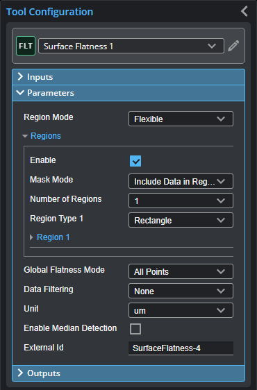
Parameters
You configure the tool's parameters in the expandable Parameters section.
| Parameter | Description |
|---|---|
|
Region Mode |
Determines how flatness measurement areas are set up on the target. One of the following: Grid Pattern: The tool determines flatness in a grid you define on the target. This option enables settings that let you set the size and location of a region that contains the grid (Grid Region setting), as well as the width and length of the grid cells (Grid Width and Grid Length). The combination of the values of these settings determines the number of cells in the grid region. Flexible: The tool determines flatness using one or more regions that you define individually on the target. |
|
Grid Region (used with Grid Pattern region mode) |
Determines the size of the grid region. (See details under Grid Pattern in Region Mode above.) |
|
Grid Width (X) Grid Length (Y) (used with Grid Pattern region mode) |
These settings determine the size of the cells in the grid. (See details under Grid Pattern in Region Mode above.) |
|
Regions |
When expanded, displays the region- and mask-related settings. |
|
Enable |
Enables regions and displays the region- and mask-related settings (see below). |
|
Mask Mode Number of Regions Region Type {n} Region {n} |
When you enable regions (see above), the tool displays additional settings related to the region type. For details on the regions supported by this tool and their settings, see Flexible Regions. For general information on regions and the difference between standard and "flexible" regions, see Regions. |
|
Global Flatness Mode |
Chooses which points the tool uses to calculate global flatness. One of the following: All Points: The tool uses all points in the measurement area (all flexible regions or the grid pattern in the region). Single Average Point: The tool uses an average of the points in the measurement area. When you choose this option, the global measurements require at least four data points to calculate the plane and statistics. This means that if you set Region Mode to Flexible, you must choose a minimum of four regions; if you set Region Mode to Grid Pattern, the size of the grid and the cells must result in at least four cells. |
|
Data Filtering |
Lets you filter scan data before the tool performs its calculations. When you use Local Percentile or Global Percentile, you must set High Percentile and Low Percentile. None - The tool performs no filtering. Local Percentile - Applies the percentile filter to local masks first, and then merges to a global mask. Global Percentile - Merges to a global mask first, and then applies the percentile filter to the global mask. |
|
Unit |
Lets you choose which units the tool uses for measurement results. One of the following:
|
|
Enable Median Detection |
When enabled, Point geometric features for the global median and the local median are output. |
|
External ID |
The external ID of the tool that appears in GoHMI Designer. For more information, see GoHMI and GoHMI Designer. |
Outputs
All tools provide measurements, geometric features, or data as outputs.
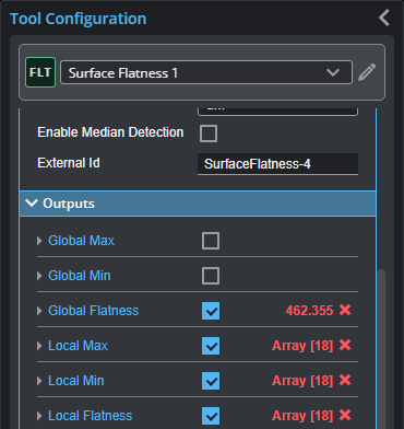
You configure the Min and Max parameters by expanding the measurement in the Outputs section. In order for a measurement to return a Pass decision, the measurement must be between maximum and minimum values; the range is inclusive.
| Measurement |
|---|
|
Global Max Global Min Global Flatness The maximum distance, minimum distance, and flatness (maximum - minimum) calculated using the valid data points from all the cells in the grid (when Region Mode is set to Grid Pattern), or all the individual regions (when Region Mode is set to Flexible). |
|
Local Max Local Min Local Flatness Arrays containing the maximum distance, minimum distance, and flatness (maximum - minimum) calculated using the valid data points from the grid cells (when Region Mode is set to Grid Pattern), or the individual regions (when Region Mode is set to Flexible). For more information on arrays, see Arrays, Batching, and Aggregation. |
| Type | Description |
|---|---|
|
Global Plane |
The plane fitted to the valid data points from all the cells in the grid (when Region Mode is set to Grid Pattern), or all the individual regions (when Region Mode is set to Flexible). |
|
Local Plane |
An array of the planes fitted to the valid data points from the grid cells (when Region Mode is set to Grid Pattern), or those from the individual regions (when Region Mode is set to Flexible). |
|
Global Average Point Global Max Point Global Min Point Global Median Point |
Point geometric features representing the global average, the global maximum / minimum, and, if Enable Median Detection is enabled, the global median. |
|
Local Average Point Local Max Point Local Min Point Local Median Point |
Arrays of point geometric features representing the local average, local maximum / minimum, and, if Enable Median Detection is enabled, local median. |