Feature Dimension
The Feature Dimension tool returns dimensional measurements from a point geometric feature to a reference point, line, or plane geometric feature. Geometric features are available as outputs from many tools, for example a Point geometric feature from Surface Position, or a line from Surface Edge. The feature creation tools such as Feature Circle Create, Feature Line Create, and so on, can also create geometric feature. For more information on geometric features, see Geometric Features.
Some examples:
- Measuring the distance between the center of a hole and an edge.
- Measuring the distance between the centers of two holes.
- Measuring the distance between a point and a plane.
- Measuring the distance between a point and the closest point on a circle.
- Obtaining the length of a stud by measuring the distance between its tip and base.
See Adding a Tool for instructions on how to add measurement tools.

|
In the following measurement descriptions, the first geometric feature is set in the Point drop-down. The second geometric feature is set in the Reference Feature drop-down. |

|
When Reference Feature is set to a feature other than a point, such as a circle or a line, measurements are between the point in Point and the nearest point on the reference feature (for example, the nearest point on a circle). |
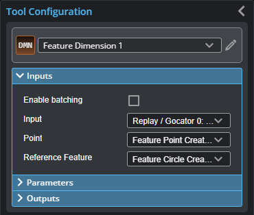
Inputs
You configure the tool's inputs in the expandable Inputs section.

| Name | Description |
|---|---|
| Enable Batching |
When Enable Batching is checked, the tool takes an array as input and processes each element in the array individually. For more information on arrays, batching, and aggregating, see Arrays, Batching, and Aggregation. |
|
Input |
The data the tool applies measurements to. |
|
Point |
A point geometric feature generated by another tool. |
|
Reference Feature |
A geometric feature generated by another tool. Dimensional measurements are calculated from the reference feature to the point in the Point input. |
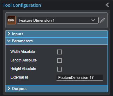
Parameters
You configure the tool's parameters in the expandable Parameters section.

| Parameter | Description |
|---|---|
|
Width Absolute Length Absolute Height Absolute |
The tools returns measurements as absolute values. |
|
External ID |
The external ID of the tool that appears in GoHMI Designer. For more information, see GoHMI and GoHMI Designer. |
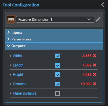
Outputs
All tools provide measurements, geometric features, or data as outputs.

Outputs section with a measurement expanded to show user-configurable decision min/max fields and an external ID
You configure the Min and Max parameters by expanding the measurement in the Outputs section. In order for a measurement to return a Pass decision, the measurement must be between maximum and minimum values; the range is inclusive.
| Measurement | Illustration |
|---|---|
|
Width Point-point: The difference on the X axis between the points. Point-line: The difference on the X axis between the point and a point on the line. For profiles, the point on the line is at the same Z position as the first point. Point-plane: The difference on the X axis between a point and a point on the plane with the same Y and Z coordinates as the first point (or the intersection of the plane and a line from the first point, parallel to the X axis). |
|
|
Length Point-point: The difference on the Y axis between the points. Point-line: The difference on the Y axis between the point and, for profiles, the nearest point on the line; currently, always zero. Point-plane: The difference on the Y axis between the point and a point on the plane with the same X and Z coordinates as the first point (or the intersection of the plane and a line from the first point, parallel to the Y axis). |
|
|
Height Point-point: The difference on the Z axis between the points. Point-line: The difference on the Z axis between the point and, for profiles, a point on the line at the same X position as the first point. Point-plane: The difference on the Z axis between the point and a point on the plane with the same X and Y coordinates as the first point (or the intersection of the plane and a line from the first point, parallel to the Z axis). |
|
|
Distance Point-point: The direct, Euclidean distance between two point geometric features. Point-line: The direct, Euclidean distance between a point and the nearest point on the line. Point-plane: The direct, Euclidean distance between a point and the nearest point on the plane. |
|
|
Plane Distance Point-point: The distance between two point geometric features. For profile data, the points are projected onto the XZ plane (always the same as the Distance measurement). Point-line: The distance between a point and a line. For profile data, projected onto the XZ plane (always the same as the Distance measurement). Point-plane: The distance between a point and a plane. For profiles, the distance is projected onto the XZ plane (always the same as the Distance measurement). |
|


